“Street views” of high Alps and huts beckon trekkers
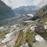
ZURICH, SWITZERLAND – The first images are now online from a joint project by the Swiss Alpine Club, Google, My Switzerland (Swiss tourism office) and the Rhaetian Railways, showing magnificent views of the high Alps taken by the Google View Trekker. The Trekker is part of Google’s Street View system but the shots are taken in areas accessible only on foot and using a backpack with 15 cameras.
The images, shot 14 August 2014, were taken on the trail from the Hospice in Grimsel to the Lauteraarhütte in canton Bern, a hut that was voted “queen of the Alps” in a Swiss online vote in May 2014.
To view the images, some of which provide rotating views, go to Google Maps and search for Lauteraarhütte.
These join the Swiss landmarks views that include 360-degree images from seven Swiss mountain resorts and 384 km of breathtaking views shot from the Rheaetian Railway lines.